|
The weather radar |
THE MAXIMUM POTENTIAL OF MEASUREMENT WITH THE ARAMIS NETWORK
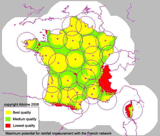
What is the quality of rainfall measurement in each point of the France territory with the ARAMIS network of 24 weather radars ? The answer to this question is not simple, because the capability of each radar to measure rainfall varies in time according to the variations of the atmosphere characteristics, with seasons but also for each rain event, and even for each rain structure. Also, no constant masks (trees, buildings, electricity pylons) can reduce the accuracy of each radar measurement. Even with correction treatments, these phenomena produce variations in the quality of the rainfall measurement. Some researchers, as Hervé Andrieu (LCPC) et Guy Delrieu (LTHE) in France, have demonstrated the importance to take into account notions of "Vertical Profile of Reflectivity" (VPR) and "Hydrologic Visibility" in the radar data use.
Using these notions, it is possible to simulate with a good reliability the rainfall measurement of a weather radar, and ALICIME has realised several important studies in this field for Météo-France, the French Met. Office (see here for example). One of the results of these studies is the estimation of the maximum potential of measurement with the current ARAMIS network of 24 weather radars. This estimation suppose a complete volumetric scan of the atmosphere for each radar, by using a great number of radar beam elevation angles. ALICIME has demonstrated that this maximum can be approached very closely by only 2 to 4 beam elevation angles, specifically chosen for each radar.
The picture below is a simplified representation of this maximum potential of measurement of the current ARAMIS network. TAKE CARE: This map do not describes the quality of the radar products actually diffused in France (contact Météo-France for this). This map only represents the variability of the maximum capabilities of measurement with the current radar network, and allows to identify the areas with the best and the lowest "a priori" quality of the radar data if this maximum is realised. As the treatment of the radar data to produce final products are not perfects, this map give a representation of the variation in quality of the radar rainfall estimations in France, with the best volumetric measurements and the best radar data processing.
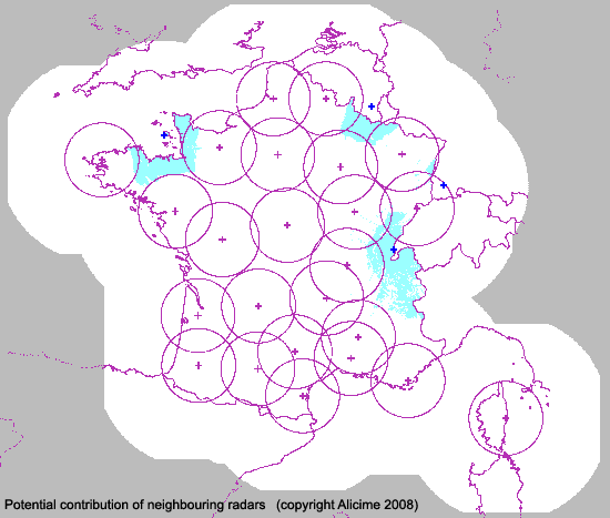
§ Potential contribution of the other European radars
In order to take into account the capabilities provided by the European weather radar networks, we have estimated the contribution to the ARAMIS rainfall measurement of 4 neighbouring radars: the radar of the Jersey Island (Channel Island close to Normandy), the radar of Wideumont in Belgium, the radar of Feldberd in Germany, and the radar La Dole in Switzerland.
The picture below present the areas of the French territory were the measurements of these radars could be interesting, particularly for the Jersey radar, the La Dole radar, and the Wideumont radar.
It is interesting to note that the Italian radars and the Spanish radars are not interesting over the French territory, but improve rainfall measurement over the Mediterranean Sea.
|
|
|
|
see also: |
|